
Updated Plan from the developers
Announced 7/10/2025 in the meeting at School 45: hoping to go before the Planning Board 7/28/2025 hoping to go before the Zoning Board of Appeals in September 2025 anticipating an 18 month time frame for construction
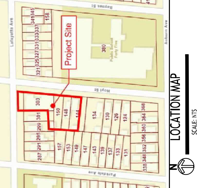
The "Project Area" map has a red line that includes two neighbor's garages, which doesn't exactly inspire confidence in the rest of the packet
- The "Project Area" map has a red line that includes two neighbor's garages, which doesn't exactly inspire confidence in the rest of the packet
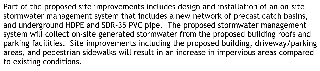
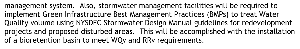
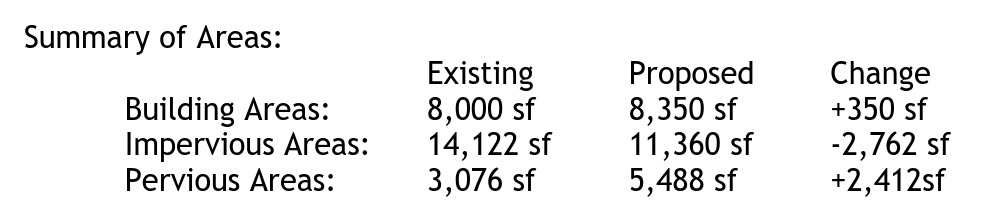
The Stormwater Prevention Plan has major inconsistencies: On the Short Environmental Assessment form, the answer to 18. Does the proposed action include construction or other activities that would result in the impoundment of water or other liquids? was No, but the stormwater plan describes "catch basins" and "a bioretention basin." Several included documents refer to 303 Lafayette as "Vacant Land", with the only included structure sited at 144 Hoyt. I have seen in a rainstorm how no rainwater runs off it. Yet the "Summary of Areas" in the stormwater plan lists 8,000 sf Existing Building Areas and 14,122 sf Impervious Areas!
The Stormwater Prevention Plan has major inconsistencies:
On the Short Environmental Assessment form, the answer to 18. Does the proposed action include construction or other activities that would result in the impoundment of water or other liquids? was No, but the stormwater plan describes "catch basins" and "a bioretention basin."
Several included documents refer to 303 Lafayette as "Vacant Land", with the only included structure sited at 144 Hoyt. I have seen in a rainstorm how no rainwater runs off it. Yet the "Summary of Areas" in the stormwater plan lists 8,000 sf Existing Building Areas and 14,122 sf Impervious Areas!
The "Custom Soil Resource Report" is hardly customized -- a Preface plagiarized from the US Department of Agriculture, a section titled "How Soil Surveys Are Made" plagiarized from starvalleycd.org, and a 36 element MAP LEGEND of which only two elements are used on the map. The map itself is just a satellite photo dating back to the property's previous owner; obviously not current. There's also a typical description of Ug-Urban land-Cayuga complex soils, which is probably irrelevant because whoever demolished the church/theater trucked a lot of new soil in from somewhere. For reference: there were signs and monitoring equipment for ASBESTOS during demolition. It's unclear why they answered No to question 20 on the Short Environmental Assessment form: "Has the site of the proposed action or an adjoining property been the subject of remediation (ongoing or completed) for hazardous waste?"
The "Custom Soil Resource Report" is hardly customized -- a Preface plagiarized from the US Department of Agriculture, a section titled "How Soil Surveys Are Made" plagiarized from starvalleycd.org, and a 36 element MAP LEGEND of which only two elements are used on the map. The map itself is just a satellite photo dating back to the property's previous owner; obviously not current.
There's also a typical description of Ug-Urban land-Cayuga complex soils, which is probably irrelevant because whoever demolished the church/theater trucked a lot of new soil in from somewhere.
For reference: there were signs and monitoring equipment for ASBESTOS during demolition. It's unclear why they answered No to question 20 on the Short Environmental Assessment form: "Has the site of the proposed action or an adjoining property been the subject of remediation (ongoing or completed) for hazardous waste?"
Green Code variances -- at the July 10 meeting they said they'd only need one, for side lot parking. To stay compliant with the rest of the Green Code's provisions, the plan needs more adjustments to the parking lot border areas, which would not be up to code as proposed. Required buffer areas are missing and/or mis-used. Sections 7.1.5 and 7.1.6 lay out the requirements for parking in zone N2-R, which include a "Type C Buffer Yard" -- 5 feet wide, with shrubbery (about one shrub every 7.2 inches), and a fence at the outer property line. 7.1.5.B.2: Where any parking lot is located along, within 50 feet of, and visible from an interior side or rear lot line that abuts any lot in an N-2R, N-3R, N-4-30, N-4-50, D-R, D-OS, D-OG, or D-ON zone, the parking lot must be screened by a Type C buffer yard, designed per Section 7.1.6. 7.1.6.B.3: Where a fence and landscaping are required within the buffer yard in accordance with Table 7A: Buffer Yards, the fence must be positioned interior to the landscaping, except for buffer yards along an interior side or rear lot line, where fences must be positioned exterior to the landscaping. However, the City Planning Board may adjust the positioning of a fence within a buffer yard to better mitigate potential impacts between the proposed project and adjacent properties. A dumpster is not one of the allowed features in any buffer yard.
Green Code variances -- at the July 10 meeting they said they'd only need one, for side lot parking.
To stay compliant with the rest of the Green Code's provisions, the plan needs more adjustments to the parking lot border areas, which would not be up to code as proposed. Required buffer areas are missing and/or mis-used.
Sections 7.1.5 and 7.1.6 lay out the requirements for parking in zone N2-R, which include a "Type C Buffer Yard" -- 5 feet wide, with shrubbery (about one shrub every 7.2 inches), and a fence at the outer property line.
7.1.5.B.2: Where any parking lot is located along, within 50 feet of, and visible from an interior side or rear lot line that abuts any lot in an N-2R, N-3R, N-4-30, N-4-50, D-R, D-OS, D-OG, or D-ON zone, the parking lot must be screened by a Type C buffer yard, designed per Section 7.1.6.
7.1.6.B.3: Where a fence and landscaping are required within the buffer yard in accordance with Table 7A: Buffer Yards, the fence must be positioned interior to the landscaping, except for buffer yards along an interior side or rear lot line, where fences must be positioned exterior to the landscaping. However, the City Planning Board may adjust the positioning of a fence within a buffer yard to better mitigate potential impacts between the proposed project and adjacent properties.
A dumpster is not one of the allowed features in any buffer yard.
This is new since the earlier plan: 12. a. Does the project site contain, or is it substantially contiguous to, a building, archaeological site, or district which is listed on the National or State Register of Historic Places, or that has been determined by the Commissioner of the NYS Office of Parks, Recreation and Historic Preservation to be eligible for listing on the State Register ofHistoric Places? b.Is the project site, or any portion of it, located in or adjacent to an area designated as sensitive for archaeological sites on the NY State Historic Preservation Office (SHPO) archaeological site inventory?" -- they answered Yes this time
This is new since the earlier plan: 12. a. Does the project site contain, or is it substantially contiguous to, a building, archaeological site, or district which is listed on the National or State Register of Historic Places, or that has been determined by the Commissioner of the NYS Office of Parks, Recreation and Historic Preservation to be eligible for listing on the State Register ofHistoric Places? b.Is the project site, or any portion of it, located in or adjacent to an area designated as sensitive for archaeological sites on the NY State Historic Preservation Office (SHPO) archaeological site inventory?" -- they answered Yes this time
Announced 7/10/2025 in the meeting at School 45: